
Archived Content
Information identified as archived is provided for reference, research or recordkeeping purposes. It is not subject to the Government of Canada Web Standards and has not been altered or updated since it was archived. Please contact us to request a format other than those available.
Chapter D1 ver. 2
Official Surveys
Table of Contents
- Survey Instructions Home
-
Part B - Agreements
-
B2 - Intergovernmental Agreements
-
Part D - Survey Standards
- D1 - Official Surveys
- D2 - Explanatory Plans
- D3 - Strata Surveys
- D4 - Condominium Surveys
- D5 - Registration and Land Use Area Plans
- D6 - Oil and Gas Surveys in Indian Reserves
- D7 - Oil and Gas Surveys in the Territories and Offshore
- D8 - Mineral Claim Surveys in the Northwest Territories and Nunavut
- D9 - Mineral Claim Surveys in Yukon
- D10 - Field Monitoring of Exterior Boundaries and Interior Frameworks
- D11 - Boundary Maintenance
- D12 - Control Surveys
- D13 - Basemapping
- D14 - Land Descriptions
- D15 - Survey Reports
- D16 - As-built Surveys
- D17 - Guidelines for the preparation of Legal Description Reports for the Individual First Nation Agreement under the First Nations Land Management Act
-
Part E - Appendices
Effective Date
This Chapter is effective April 1, 2008. It replaces Chapter D1 as published April 1, 2004 in the General Instructions for Surveys of Canada Lands, e-Edition.
Chapter Sections
- General
- Monumentation
- Adjustment and Testing of Measuring Equipment
- Survey Methods
- Bearings
- Accuracy
- Connections / geo-referencing
- Location of Natural Boundaries
- Surveys in Coordinated Survey Areas
- Official Field Notes
- Official Plans
- Returns of Survey
- Schedule D1-1, Table of Reference for Right-of-Way Areas
- Specimen Plans
General
- An official survey is a survey of Canada Lands for which a plan is confirmed under Part II or Part III of the Canada Lands Surveys Act.
- Whether or not an official survey is required depends on the type of land interest for which the plan will be used. The types of land interests requiring official surveys are outlined in legislation or interdepartmental / intergovernmental agreements between the Surveyor General and the government departments having administration and control of the land. A government department may be a federal, provincial, territorial or an aboriginal government department.
- Specific survey instructions are required for official surveys.
- If the boundary of the Canada Lands being surveyed is common to provincial lands then all applicable provincial laws and regulations pertaining to surveys must also be followed. If there is any conflict between federal and provincial survey requirements, consult the regional office of the Surveyor General Branch. Generally the requirements leading to the higher standard of survey are to be followed.
Monumentation
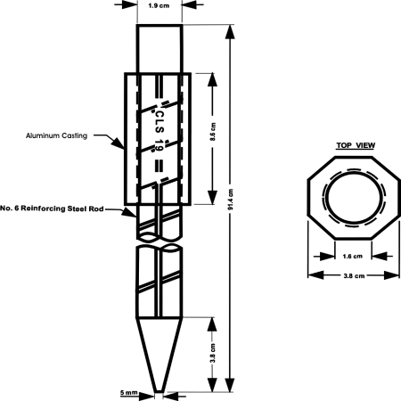
- For surveys situated in the territories, set CLS 77 posts (see
Figure 1) at all corners unless otherwise specified in these general
instructions or in any specific instructions.
-
 Text
description of Figure 1
Text
description of Figure 1
Figure 1 - CLS 77 Post
-
- For surveys of Canada Lands situated in the provinces, surveyors
may use the same or approved similar monument type used in that
province provided that the monument is of ferrous material and is not
less than:
- 75 cm in length and 1.5 cm square (or diameter) for surveys defining the jurisdictional boundaries; and
- 60 cm in length and 1.2 cm square (or diameter) for internal allotment including parcels that adjoin a jurisdictional boundary.
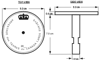
- When bedrock or a large boulder is encountered less than 30 cm
below the ground surface, cement a CLS standard rock post (see figure
2) in a hole drilled in the rock. Where a CLS standard rock post is
not available a CLS 77 post, or provincial equivalent, may be cut down
and cemented into the rock. The top of the rock shall be cleared of
all earth at the monument location.
-
 Text
description of Figure 2
Text
description of Figure 2
Figure 2 - CLS Standard Rock Post
-
- Block corners, jurisdictional boundaries, and other principal
corners which fall in concrete or asphalt shall be marked with
monumentation specified in paragraphs 5 and 6 or approved
alternatives. For other corners the following may also be used to mark
or reference the corner:
- in concrete or similar surfaces a drill hole with a lead plug having a tack therein; or
- in asphalt an iron bar at least 30 cm long driven through the asphalt flush with the surface.
Monument Markings
- Mark every monument placed in a survey as follows:
- with the letters "IR", for monuments on Indian Reserve boundaries, and "NP" for National Park boundaries;
- on capped posts, with the year and a distinguishing letter or number; and
- on CLS 77 posts situated in the territories:
- with the letters "R/ W" on the side of the monument facing the right-of-way, for monuments on right-of-way boundaries;
- with the letter "R" on the side of the monument facing the road, for monuments on road boundaries;
- with lot and block numbers, for monuments in subdivisions; and
- with a distinguishing number for monuments marking parcels and right-of-ways in rural and remote areas such as:"1L1000, 2L1000.... , R25, R27, R28, etc."
- In addition to, or as an alternative to paragraph 9 above, when using provincial monumentation, the monument should be marked in accordance with the provincial practice.
- Witness monuments, in the case of capped posts and CLS77 posts, shall be marked with the letters "WT" followed by the distance and the approximate direction from the monument to the witnessed corner (e.g. WT 15 N). When using provincial monumentation other than capped posts, the monument or marker post should be marked in accordance with the provincial practice.
- If monuments also define section and quarter section corners, the monuments shall include markings in accordance with the provincial practice.
Ancillary Monumentation
- Ancillary monumentation shall accompany all placed monuments unless conditions make it impractical. The surveyor shall determine the type of ancillary monumentation to be used considering the nature of the ground, the terrain, safety and local custom.
- Ancillary monumentation may be:
- reference devices such as bearing trees or reference posts which can be used to restore the position of the monument;
- marker posts used to protect monuments from destruction and make them easier to find, or used to help locate the position of boundaries; or
- part of the monument such as pits and earth or stone mounds.
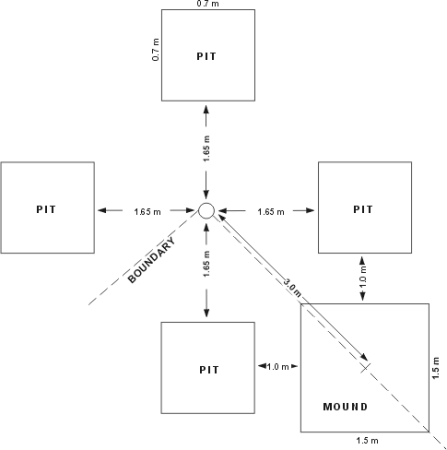
- If new pits and earth or stone mounds are made then they must be made in accordance with the pattern in figure 3. If existing pits and mounds are restored then they must be restored to their original form.
- If bearing trees are used as ancillary monumentation, then they
shall be made for monuments where there are suitable trees at
reasonable distances from the monument. Three trees are preferred.
Blaze the side of the tree facing the monument and scribe on the blaze
the letters "BT". Record the description of the bearing tree (kind and
diameter) and the horizontal distance and direction from the monument
to the blaze. The direction shall be referred to the reference
meridian used for the survey.
-
 Text
description of Figure 3
Text
description of Figure 3
Figure 3 - Positioning of Pits and Mound
- Notes:
- 1. Pits are 0.4 m deep.
- 2. Mound is pyramid shaped and 0.7 m high.
- 3. Rotate pits to avoid obstacles; if necessary one pit may be omitted.
-
- If reference posts are used then they shall:
- be of magnetic content;
- be placed at approximate 120° to each other in relationship to the monument or control survey marker;
- be placed in as safe a place as possible;
- be no smaller than 1.2 cm square (or diameter) x 45 cm;
- be placed in groups of three; and
- the type of reference posts placed, their markings and the horizontal distance and direction from the monument to each reference post shall be recorded.
- Marker posts used to protect monuments and make them easier to find
may consist of:
- a T-section, angle or similar type of fencing post about 1.5 m long firmly driven into the ground or cemented into a drilled hole in rock. It shall be placed, if possible, 0.3 m from the monument. A plaque with suitable markings shall be attached to the marker. The plaque should face the monument. Record the markers position relative to the monument;
- a pressure treated wooden post at least 1.2 m long, 10 cm square, bevelled at the top. It shall be firmly planted if possible on the boundary approximately 0.3 m from the monument. This marker shall be marked with the lot numbers and if on a boundary of an Indian Reserve with "IR". Record its position relative to the monument;
- a wooden stake 5 cm square, 60 cm long placed approximately 0.3 m from the monument. This marker is suitable for townsites and subdivisions. Its position does not need to be recorded; or
- any other object, such as a stone mound, fibreglass marker etc., acceptable to the Surveyor General Branch.
- Make ties from monuments to permanent features such as building corners, bridge abutments etc., to assist in finding or re-establishing the position of a monument in the future.
- If marker posts are placed to help locate the position of
boundaries they shall be placed on the boundaries at intervals of
approximately 300 metres, or other distance as specified in the
specific survey instructions, and may consist of the following:
- a T-section, angle or similar type of fencing post about 1.5 m long firmly driven into the ground or cemented into a hole drilled in rock;
- a pressure treated wooden post 10 cm square, at least 1.2 m long firmly planted into the ground; or
- any other object acceptable to the Surveyor General Branch.
- Markers on Indian Reserve or National Park boundaries may be augmented with an identification plaque attached to them. The plaque shall be inscribed with suitable wording such as "Indian Reserve Boundary" or "National Park Boundary".
Placing of Monuments
- On all artificial boundaries being surveyed place monuments:
- at each change of direction of straight line boundaries;
- at the beginning and end of curves, at points of changes of curvature and at points where straight line boundaries intersect curves;
- at intervals not exceeding one kilometre for straight line boundaries, and preferably in locations where the monuments are intervisible; and
- at points of intersection with previously surveyed boundaries, except in the cases outlined in paragraphs 23 and 24.
- Placing monuments at points of intersection with previously
surveyed boundaries is not required in the following situations:
- where an existing parcel or subdivision is not being used, or is
not likely to be used, for any purpose, providing:
- the boundary of the parcel or subdivision is not part of a main survey fabric, such as a section line or concession line;
- there are no existing rights based on the parcel or subdivision; and
- sufficient connections are made to the parcel or subdivision to illustrate the relationship on the plan of survey;
- where in the resurvey of a jurisdictional boundary, such as the exterior boundary of an Indian Reserve or National Park, the boundaries of parcels adjoining the jurisdictional boundary do not affect the position of the jurisdictional boundary. However the monuments for the parcels adjoining the jurisdictional boundary must be searched for and the results of the searches reported;
- where the boundaries intersect surveyed sub-surface parcels such as mineral claims. However sufficient connections shall be made to the boundaries of the claim to illustrate the relationship on the plan of survey;
- where the point of intersection has been previously monumented by an existing survey. However sufficient connections shall be made to illustrate the relationship on the plan of survey;
- where the boundaries intersect existing surveyed limited interests that have been connected to the survey fabric in the close vicinity of the survey; and
- where the boundaries intersect existing boundaries of well sites and access roads surveyed under Chapter D6 (Oil and Gas Surveys in Indian Reserves).
- where an existing parcel or subdivision is not being used, or is
not likely to be used, for any purpose, providing:
- When surveying a right-of-way or road:
- only one limit of the right-of-way or road must be monumented unless the right-of-way or road is over 30 m in width, in which case both limits must be monumented. The requirement to monument both sides may be relaxed by specific survey instructions if the right-of-way or road crosses large areas of vacant crown land; and
- If a right-of-way for a limited interest, such as an access right-of-way or utility right-of-way, crosses a lot or a series of adjoining lots, only the intersection with the first and last boundaries crossed, or with others as specified in the specific survey instructions, has to be monumented.
- Where only one limit of a right-of-way is being monumented and a deflection point on that limit cannot be monumented or witnessed, monument the corresponding deflection point on the opposite limit. In addition, monument both limits at the next deflection point in at least one direction.
- Monuments marking parcels being replaced by parcels of a new survey that may cause confusion to the layperson should be removed if they are of no value for future surveys. Make or ensure that there are sufficient ties to enable the position of the monument to be maintained.
- If it is impossible, or inadvisable, to monument a point of deflection or a point of intersection, then place a witness monument as near as practical to the true location, on one of the boundaries being surveyed. Do not place a witness monument if the corner is already defined by a witness monument. Record the distance and direction from the witness monument to the point of deflection or intersection and the reason why the point could not be monumented.
- If the nature of the terrain prohibits the re-establishment of a monument on a straight line boundary in its original position, and it is not necessary to place a witness monument because the position does not mark a lot corner, then a new monument may be erected at a new location on the boundary as close as possible to the original position. Record the reason why the monument cannot be re-established in the original position.
- Where an artificial boundary terminates at a natural boundary place a monument on the artificial boundary far enough from the natural feature so that it is reasonably safe from destruction. Measure and record to the nearest 0.1 m the distance, along the artificial boundary, from the monument to the natural boundary.
- When placing a new monument on an existing monumented curve or straight line boundary, sufficient evidence on the boundary being retraced must be searched for and recorded. The new monument shall be placed on the line joining the two adjacent monuments marking the boundary. Should the adjacent monuments be obliterated, lost or disturbed, the closest best evidence that straddles the new monument shall be used. The distance and direction between the new monument and the existing monuments shall be measured and recorded.
- All obliterated monuments used to retrace a boundary shall be restored. The positions of all lost or disturbed monuments, which are used to re-establish a boundary should be re-established.
Cutting out and Blazing Lines
- An environmental assessment and review process may be required by the administering department for line cutting and other survey work which may damage the environment. Before starting any line cutting work ensure that the requirements of any environmental assessment and review will be followed. In case of conflict with any survey standard, consult the regional office of the Surveyor General Branch.
- For jurisdictional boundaries, in addition to the requirements in this part, all line cutting shall be done in accordance with provincial or territorial government requirements and in accordance with any requirements of the administering department.
- When cutting and blazing boundaries take all reasonable precautions to avoid causing damage to private property. Every effort must be made to inform each owner affected and to respect any concerns they may have.
- Unless otherwise specified in the specific survey instructions, in
an environmental assessment and review process, or in any provincial
or territorial government or administering department requirements, in
undeveloped wooded areas:
- cut out all boundary lines and blaze suitable trees to make the boundary recognizable as a cut line. Remove all fallen trees, logs, and brush from the cut line; and
- blaze suitable trees within 2 metres and on both sides of a boundary. Blaze the side of the tree facing the boundary line and each of the sides at right angles to this side. The blazed trees are not intended to mark the boundaries or the limits of the parcels. They are blazed to assist in finding the boundaries.
- If practical, survey along the actual boundaries so that only one line need be cut out. This will eliminate the possibility of traverse lines being mistaken for boundaries in the future. Where it is impractical to survey along the boundaries minimize cutting and, if possible, traverse along nearby clearings, roads, or trails.
- Line cutting and blazing are not required in developed townsites or subdivisions, for rights-of-way, or where boundaries follow features such as fences, hedges, or tree lines.
- Unless otherwise specified by specific survey instructions, in undeveloped multi-lot subdivisions consisting of lots and blocks, cut out all block outlines and the rear boundaries of all lots. For lots smaller than one hectare, it is only necessary to cut out every fifth sideline. For lots larger than one hectare every second sideline should be cut out.
- In the township system, where road allowances are adjacent to Indian Reserves or National Parks, the actual reserve or park boundary may not have been monumented or cut out in the original survey. Any new monumentation, boundary line cutting or blazing shall be done on the actual boundary.
- The cutting of merchantable timber should be avoided. If merchantable trees are left on the boundary, they should be blazed with 3 blazes placed vertically (one above the other) on each side of the tree where the boundary line intersects the tree. Record the size and type of the tree and the distance from the nearest monument to the blaze.
Adjustment and Testing of Measuring Equipment
- All equipment used in the survey must be in adjustment, in calibration and standardized. The surveyor must keep records of calibration and standardization results and carry out sufficient analysis of the data to prove that the equipment is operating to the manufacturer's specifications.
- Records of calibration and standardization results and copies of any analysis carried out must be retained so that, if requested, they can be submitted as part of the returns of survey.
- Indirect positioning systems, such as the Global Positioning System (GPS), must be tested on a control network acceptable to the Surveyor General Branch. Records of tests must be retained so that, if requested, they can be submitted as part of the returns of survey.
Survey Methods
- It is preferable that straight lines, rather than curved lines, be used for boundaries. New spiral curve boundaries shall not be created. If it is legally possible, circular curves shall be substituted for existing spiral curves.
- A surveyor may adopt the boundary of a prior official survey
without actual retracement only if the surveyor personally measured
that boundary and provided that:
- the field notes of the previous survey are recorded in the Canada Lands Surveys Records (CLSR);
- the accuracy of the previous survey achieves the accuracy requirements specified in paragraphs 53 to 57 of this Chapter;
- the monuments marking the boundary are in good condition, are in their original position, and a report of their condition is included in the field notes for the new survey; and
- the field notes for the new survey indicate which measurements are adopted.
- When a lot is to be created beside an unsurveyed road or portion of road, the limit of the road common to the lot must be surveyed and additional monuments placed on the road limit on both sides of the lot to provide for any future extension thereof.
Bearings
- Bearings may in order of preference be controlled by or be derived
from:
- Coordinated Control Monuments in a Coordinated Survey Area;
- federal or provincial control survey markers;
- GPS baselines of a minimum length of 100 metres;
- monuments established in a previous legal survey for which the plan is recorded in the CLSR. The distance between boundary monuments selected should be sufficient to enable legal survey accuracy standards to be met, and over 100 m, if possible; and
- astronomic observations for azimuth providing that the accuracy requirements for legal surveys are attained.
- Bearings derived by GPS methods or from control monuments should be grid bearings referred to the appropriate map projection in which the survey is situated.
- Angles and bearings shall be expressed in degrees, minutes and seconds.
- The maximum allowable angular misclosure is 20√n seconds (n=number of angles measured in the traverse loop or between lines of bearing control).
- For surveys of Canada Lands situated in the provinces and Yukon, if
a meridian to which bearings are to be referred to is not specified in
the specific survey instructions for the survey, refer the bearings to
one of the following meridians:
- if the survey is geo-referenced, to the central meridian of the appropriate map projection;
- the customary meridian in the area of the survey; or
- if one of the above two methods is not applicable, then to the meridian through a point, preferably monumented, central to the survey.
- For surveys situated in the Northwest Territories and Nunavut, the UTM map projection and the appropriate central meridian are to be used for all surveys.
Accuracy
- The minimum accuracy standard for legal surveys is defined by the
ellipse showing the 95% confidence region for the positioning of one
station relative to another. The semi-major axis of this ellipse in
centimetres (r) with respect to another station must be less than or
equal to C( d+ 0.25) where:
- C = an assigned value depending on the accuracy requirement; and
- d = the distance in kilometres to any station.
- For surveys involving the surveyor's own work, C is assigned the
value 8. The following table illustrates how various distances affect
the semi-major axis of the 95% confidence region of one station with
respect to another, parts per million (ppm) and the accuracy ratio for
r = 8( d+ 0.25):
Semi-major axis r8 d (km) r (cm) ppm ratio 0.01 2.1 2100 1/480 0.03 2.2 733 1/1360 0.10 2.8 280 1/3570 0.50 6.0 120 1/8033 1.00 10.0 100 1/10000 - For surveys using the surveyor's own measurements combined with
previous surveyors' measurements, C is assigned the value 15. The
following table illustrates how various distances affect the
semi-major axis of the 95% confidence region of one station with
respect to another, parts per million (ppm) and the accuracy ratio for
r = 15( d+ 0.25):
Semi-major axis r15 d (km) r (cm) ppm ratio 0.01 3.9 3900 1/260 0.03 4.2 1400 1/710 0.10 5.3 530 1/1890 0.50 11.3 225 1/4420 1.00 18.8 190 1/5320 - If the accuracy for a connection, involving a previous surveyor's work does not meet legal survey standards, the connection shall be remeasured or verified using an independent method.
- See Appendix E4 for additional information regarding the concept of confidence region for legal surveys and the application of this standard for legal surveys.
Connections / Geo-referencing
- All surveys shall be connected to one, and preferably two, monuments of the closest existing legal survey provided a legal survey lies within one kilometre of the current survey. Specific survey instructions may exempt connections between the new survey and nearby existing legal survey in cases where both the new survey and nearby existing legal survey are accurately geo-referenced to NAD83CSRS or other approved reference system.
- In cases where GPS methods are used to control or measure all or part of the boundaries in the survey, all monuments within the survey shall be geo-referenced to NAD83CSRS to an absolute accuracy of 20 cm or better.
- All remote surveys shall be geo-referenced to an absolute accuracy
of one metre or better. A remote survey includes but is not limited to
the following:
- surveys that are not connected to the cadastral survey fabric of inhabited urban or rural areas;
- surveys connected to existing remote legal surveys; and
- surveys within remote Indian Reserves which have less than twenty parcels.
- Specific survey instructions may exempt the geo-referencing specified in paragraphs 59 and 60 in cases where the survey is connected to an accurately geo-referenced existing legal survey.
- If it is difficult to meet the 20 cm absolute accuracies for all of the monuments in the survey then an authorized regional representative of the Surveyor General Branch may reduce the absolute accuracy requirements for some of the monuments. This may occur with larger surveys where there is an extensive conventional survey between GPS control points.
- Any structure, fence, hedge, or similar features which are close to, or extend over a boundary being surveyed shall be tied in and related to the boundary.
Location of Natural Boundaries
- The position of natural boundaries can be determined by any method, provided the boundary can be plotted at the final plan scale to an accuracy of 0.5 mm.
- If a boundary of a parcel being surveyed and monumented is the limit of a reservation that is measured from a natural boundary then the natural boundary shall be located to an accuracy of at least 0.5 of a metre for plan scales greater than 1: 1,000. Where a parcel of land being surveyed in the Yukon excludes a reservation along a body of water, such as the 30.48 metre reserve, locate the ordinary high water mark according to paragraph 64 and survey and monument a series of artificial boundaries that excludes the reservation.
- If the natural boundary is plotted from aerial photographs, maps,
imagery or other information source that the surveyor has not
prepared, the surveyor shall inspect the boundary on the ground:
- to verify (including if necessary taking sufficient measurements) that the plotting accuracy of 0.5 mm at the final plan scale (or the accuracy specified for the establishment of the limit of a reservation) can be achieved; and
- to clearly mark the position of the natural boundary on the photograph, map, imagery or other information source.
- Aerial photographs, maps, imagery or other information source that have the position of natural boundaries marked on them under subparagraph 66 b. must be signed and dated by the surveyor. They form part of the returns of survey and will be recorded in the CLSR.
- Natural boundaries located from a photogrammetric or mapping
process require the following support documentation:
- a signed and dated surveyor's report providing details of the method used;
- a manuscript showing the control points used to prepare the plot;
- descriptions for all control stations in a format acceptable to the Surveyor General Branch;
- aerial photographs and diapositives (if requested) from which the product was produced;
- if applicable, a copy of the numerical adjustment in a format acceptable to the Surveyor General Branch; and
- if requested, the coordinates of the natural boundary or a digital file of it in a form acceptable to the Surveyor General Branch.
Surveys in Coordinated Survey Areas
- Every legal survey carried out within, or partly within, a
Coordinated Survey Area shall be connected to Coordinated Control
Monuments so that the survey can be closed through the connections.
Connections shall be made from at least two well separated monuments
of the legal survey to:
- the two Coordinated Control Monuments that best straddle the survey;
- all Coordinated Control Monuments within the perimeter of survey; and
- all Coordinated Control Monuments within 150 m of the survey.
- Bearings shall be derived from one or more pairs of Coordinated Control Monuments or alternatively from monuments of a survey previously integrated in the Coordinated Survey Area.
- When subdividing or consolidating previously surveyed parcels which have been integrated into a Coordinated Survey Area, new connections to the control network are not mandatory, however connections should be made to Coordinated Control Monuments within or near the parcel being subdivided.
- If the surveyor finds that a Coordinated Control Monument is disturbed or if it appears that the coordinates are in error it shall not be used in the survey and the surveyor shall report the matter to the regional office of the Surveyor General Branch.
Official Field Notes
- Official field notes may be prepared in whichever of the following
forms is the most suitable for clarity and completeness:
- plan form. Except where otherwise specified in this Chapter, follow the guidelines in Appendix E3;
- incorporated with the plan of survey. This form is appropriate only where the addition of field note information does not clutter up the plan. The title of the plan should read "Plan and Field Notes of Survey of .............."; or
- book form. This form shall be either the original field records if they are clear and easily understandable, or a clear and understandable compilation of the field records.
- The field records shall be held by the surveyor, and, even though official field notes have been filed in the CLSR, a surveyor may still be required to submit the field records or copies of the field records.
- Electronic field records may be submitted; however, they must be accompanied by a hard copy which is well organized with sufficient diagrams and annotations to be clear and easily understandable. The hard copy will be the official field notes and must comply with all provisions of this Chapter regarding official field notes.
- Provide in the title of the official field notes:
- the new parcel designators or other descriptive heading in cases where no parcel designator is assigned;
- information specified in Appendix E3, paragraph 14; and
- the period in which the field work for the survey was carried out and the name and qualifications of the surveyor in the following form: "This survey was executed during the period of (date) to (date), by (surveyor's name) CLS."
- Provide in the legend of the official field notes:
- a statement describing the type of bearings (e.g. grid), how the bearings were obtained (i.e. the type of observations and points at which the observations were made or the line from which bearings were adopted) and the meridian to which the bearings are referred;
- the source of any derived data involved in the survey;
- the CLSR number of any plan or reference to aerial photographs, imageries or other data used to plot the position of any natural feature or boundary shown in the official field notes;
- if a coordinate system is used, a description of it, including a statement identifying the conversion factor used to convert ground level distance to the projection plane;
- an explanation of all abbreviations used which are not listed in Schedule 3 of Appendix E3; and
- if GPS observations are used to derive some or all of the dimensions of boundaries, a statement describing the GPS observations shall be added such as "GPS observations were used to derive part (or all) of this survey" or "Real time kinematic GPS observations were used to derive part (or all) of this survey".
- Show in the diagram of the official field notes:
- a list of all published and adjusted coordinate values (e.g. UTM) of control survey markers used or established in the survey with a description of the marker. The list shall include a statement that specifies how the coordinates were derived;
- ellipsoidal or orthometric heights of GPS control stations. Include a statement that specifies how the heights were derived, including the geoid model and the datum to which they are referred, if applicable;
- the combined scale factor for each monument and control station unless one combined scaled factor for the entire survey is appropriate;
- a distinct symbol for GPS control stations and an abbreviation (e.g. "GPS") beside monuments which are also GPS control stations;
- a sketch of the control network if it is not apparent in the diagram at plan scale;
- where a survey is geo-referenced, a listing of coordinates of main monuments, such as those located at block corners, curve terminations, and deflection points, need to be tabulated;
- bearings and distances reduced to horizontal at general ground level for every observed boundary and of traverse connections to natural boundaries. Bearings and distances of other traverse courses and offset lines should also be shown on field notes only products. These additional ties should not be shown on combined plan and field notes;
- the radius, arc length, chord distance and chord bearing of each circular curve boundary and if the curve is non tangential, the radial bearing at the beginning and end of curve;
- the length, the starting point radius and the terminal point radius of each spiral curve boundary and the lengths and bearings of chords between adjacent monuments on the spiral curve boundary;
- all boundaries within the limits of and adjacent to the survey;
- all evidence searched for or placed indicating what was found, restored and placed;
- descriptions of the types, condition and the markings of monuments and ancillary monumentation;
- the designation of each lot, parcel, road, right-of-way, etc. involved in and adjacent to the survey;
- the surveyed connection to and descriptions of all significant natural and man made features which are close to or extend over the boundaries of the lands being surveyed. GPS (and radial) connections to features such as a natural boundary should be shown in a tabular format that lists either coordinates or bearings and distances. If coordinates are listed, include those of the control base station in the table from which observations are made and a statement that describes the type of coordinates listed; and
- a north arrow.
- Show in the official field notes the survey work carried out to verify measurements between monuments which differ from previous plans in an amount exceeding the accuracy requirements for legal surveys outlined in this Chapter.
- For clarity, diagram information such as distances, directions and monument descriptions may be shown using detail insets, not necessarily to scale, or tables.
- The surveyor shall provide on the plan a statement of responsibility in accordance with section 38 of the Canada Lands Surveyors Regulations. If the statement of responsibility is not in the form of "Certified Correct", the surveyor shall consult the Surveyor General to determine if the statement meets the requirements of the Surveyor General under section 17 of the Canada Lands Surveys Act.
Official Plans
- Official plans shall be prepared in accordance with the guidelines in Appendix E3.
- An official plan shall be similar in form to the appropriate specimen plan SP1- 1 to SP1- 5.
- An official plan must clearly document the nature and position of the boundaries dealt with by the official survey.
- The title of the official plan shall include the new parcel designators or other description in cases where no parcel designator is assigned and other information specified in paragraph 14 of the Appendix E3.
- In the title block give the date of the survey and the name and
qualifications of the surveyor in the following form:
- "by ............., CLS, in ........."
- Provide in the legend:
- a statement describing the type of bearings (e.g. grid) how they were obtained (i.e. the type of observations and the points at which observations were made or the line from which bearings were adopted), and the meridian to which the bearings are referred;
- the CLSR number of any plans or reference to aerial photographs, imageries or other data used to plot the position of any natural feature or boundary shown on the plan; and
- the CLSR number(s) of the field notes for the survey dealt with by the plan.
- Show in the diagram of the plan:
- a heavy black line, between 1 and 1.5 mm in width coinciding with the exterior boundaries of the lands dealt with by the survey or, in the case of a boundary survey, the boundary;
- the type and position of all monuments used in the survey;
- the type, position, and identification number of any monument or control survey marker to which a surveyed connection has been made;
- the designation of each new lot, block, parcel, road, or right of way dealt with by the plan;
- the width of each road, right-of-way or easement dealt with by the plan;
- the designation, according to plans of record, including registration plans, of each previous lot, block, parcel, road, right of way or easement involved in and adjacent to the survey;
- plan numbers of other plans, such as registration plans or Regional Surveyor plans, for which a registry abstract was opened or for which an interest was issued, or which otherwise affects the survey;
- if lots are subdivided or consolidated, the designation of the underlying parent lots, the plan record numbers and lot boundaries in phantom. It is only necessary to show the last generation of underlying plans;
- the nature and position of all significant natural and man-made features which are close to or extending over the boundaries of the lands being surveyed. Other features within or outside of the lands being surveyed may also be shown;
- names of features according to the Gazetteer of Canada, published government maps or local usage;
- the bearing and the distance reduced to the horizontal at general ground level of each straight line boundary dealt with by the plan;
- distances and bearings along the boundary lines to monuments used to create or re-establish boundaries dealt with by the plan;
- the radius, arc length, chord distance and chord bearing of each circular curve boundary and if the curve is non tangential, the radial bearing at the beginning and end of curve;
- the length, starting point radius and terminal point radius of each spiral curve boundary and the lengths and bearings of chords between adjacent monuments on the spiral curve boundary;
- the area of each surveyed lot, road or right-of-way, except for roads within subdivisions where only a total area is required;
- where a survey is geo-referenced, a listing of coordinates of main monuments, such as those located at block corners, curve terminations and deflection points need to be tabulated;
- the ordinary high water mark of all water bodies within or adjacent to the lands being surveyed for returns of survey in the territories; and
- where a Crown administered parcel of land being surveyed in the Northwest Territories or Nunavut borders on a body of water, plot and label a dashed line 30.48 metres from the ordinary high water mark within the parcel being surveyed.
- Where a lot is surveyed beside an unsurveyed road, only the lot should be dealt with on the plan and no reference to the road should be made in the title, however the survey of the road limit should be shown in the body of the plan.
- If it is not apparent in the plan title or in the diagram of the
plan that parcel(s) shown on a previous plan are to be replaced with
parcel(s) shown on the new plan, then a prominent note should be added
to the plan in the form:
- Parcel(s)........ dealt with by this plan replace(s) parcel(s) (or part(s) of parcel(s)) ............ dealt with by plan(s) ........."
Compiled Plans
- In certain situations, official plans may be compiled from existing
survey information shown on field notes recorded in the CLSR; these
plans may only be prepared under specific survey instructions.
Compiled plans may be prepared for various purposes including;
- consolidation of two or more existing parcels into one;
- consolidation of several surveys over a large area into one plan; and
- elimination of lot remainders by incorporating them into the "area dealt with" when surveying out smaller parcels from larger ones and other similar uses.
- Any compiled boundaries that are to be confirmed under the Canada Lands Surveys Act or approved under Territorial Land Titles Acts must have been monumented to Canada Lands Survey standards or have been previously confirmed (or approved) boundaries under those Acts.
- Information on the compiled plan should be obtained from the most recent official plans and/or field notes of survey in the Canada Lands Surveys Records (CLSR). Documents of record in provincial land titles or land registry offices may only be used if copies are recorded in the CLSR.
- No boundaries can be created on a compiled plan by computing the bearing and/or distance between two points. The bearing and distance between the two points must have been measured or calculated previously.
- The distances and bearings of boundaries used for the purpose of compiling plans must be converted to a common unit (e.g. metres) and/or rotated to a common meridian as the case may be.
- The method of converting distances and/or rotating bearings applied
in the compilation shall be:
- explicitly stated in the legend of the plan; and
- explained in detail in the survey report including;
- how angular relationships were maintained; and
- bearing rotation and/or convergence values applied.
- Bearings and distances used must provide a closure meeting the specification in paragraph 55 of this Chapter.
- The inclusion of a statement explicitly stating that the plan is
compiled and not a current survey should be boldly displayed in the
legend in the following form:
- for a fully compiled plan: "The boundary information on this plan has been compiled from field notes of records as noted and no new field work was performed to verify the monuments, measurements or potential boundary encroachments"; or
- for a partially compiled plan: "The boundary information on this plan has been compiled from field notes of records as noted and no new field work was performed to verify the monuments, measurements or potential boundary encroachments, unless otherwise shown."
- Show in tabular form, in the title block/legend area of the plan
the compilation information including: name of surveyor, type of
commission, years of survey, field notes type, and CLSR record number
(and other registry number if applicable) used for the preparation of
the compiled plan in a manner similar to:
- "R.Penteur, DLS, surveyed in 1945, Plan and Field Notes, 56789 CLSR, 4321 LTO
- Doug Deep, DLS, surveyed in 1955, Field Notes of Survey, 67890 CLSR
- Will Testify, DLS, surveyed in 1965, Plan and Field Notes, 78901 CLSR
- N. Croachment, CLS, surveyed in 1975, Field Notes of Survey, FB 34567 CLSR".
- Plan must differentiate what has been copied or not and such information be prominently displayed on the plan body and/or legend-title block area.
- Field note ties and dimensions pertaining to improvements on the lands, such as buildings, etc. are not to be copied.
Official Plans in Coordinated Survey Areas
- In addition to the information outlined above, official plans in
Coordinated Survey Areas shall also show:
- in the legend, a statement identifying the combined conversion factor (the product of the elevation factor and the projection scale factor) used to convert ground level distance to the projection plane; and
- in the diagram, all Coordinated Control Monuments relevant to the survey.
- The integration of surveys into a Coordinated Survey Area shall be based on the principle of working from the whole to the part. When calculating coordinates, discrepancies shall be distributed proportionally in each part of the survey (the coordinates of Coordinated Control Monuments are to be assumed errorless unless there is evidence that a monument has been disturbed).
- The plan shall show bearings and distances reduced to the horizontal at general ground level.
- The returns for official plans in Coordinated Survey Areas shall include the coordinate datum, the date of the coordinates and a listing of coordinates of all relevant coordinated control monuments and boundary monuments found or established in the survey. This list shall be suitably annotated so that the monuments can be identified on the plan. In the case of extensive subdivisions only the main monuments, such as those located at block corners, curve terminations, deflection points and any other points required to obtain approximate maximum intervals of 150 m between coordinated points, need be tabulated.
Official Plans of Right-of-Way
- The following guidelines should be followed when showing
rights-of-way on official plans:
- the full extent of each of the underlying lots or parcels affected by the right-of-way shall be defined on the plan;
- if the official plan is prepared for the sole purpose of defining
the extent of a right-of-way, the title shall be in the following
form:
- "Plan of Survey of
- (ROAD, PIPELINE, POWER LINE)
- RIGHT-OF-WAY
- Through LOTS 5, 6, and 7 etc."; and
- if the official plan deals with other lots and/or parcels in
addition to the right-of-way and the right-of-way is a separate
parcel, the title shall be in the following form:
- "Plan of Survey of LOTS 5, 6, and 7 and
- (ROAD, PIPELINE, POWER LINE)
- RIGHT-OF-WAY".
- If the right-of-way is monumented on one side only, it is sufficient to dimension only the monumented side if the other side is parallel to the monumented side. In addition, show the width of the right-of-way.
- If the right-of-way is for a limited interest such as an easement,
access agreement or permit, which will not cause a severance of the
lot or parcel in which it lies, the right-of-way should be shown on an
explanatory plan. However, if satisfactory to the administering
department, a right-of-way for a limited interest (whether monumented
or not) may be shown on an official plan dealing with other parcels.
In such a case:
- the boundaries of the right-of-way should be shown by dashed lines so it is clear that a severance is not intended;
- the plan should clearly show the lots or parcels that the right-of-way affects;
- the right-of-way should be labelled on the diagram of the plan as access right-of-way, utility right-of-way, etc.; and
- the title should not include a designation for the right-of-way.
- A table of reference may be added to right-of-way plans to show areas of land taken from parent parcels of land (See Schedule D1-1).
Approval and Confirmation of Official Plans
- Place the appropriate endorsement certificates in the spaces as indicated on the specimen plans.
- The plan shall be approved by the duly authorized officer(s) of the department of the Government of Canada, Commissioner or First Nation administering the lands.
- Upon the approval of the plan as specified in paragraph 111, the Surveyor General or a person designated by the Surveyor General to confirm such plans, will confirm the plan if the survey and plan conform with these general instructions and the specific survey instructions. The plan will be deemed to be an official plan upon confirmation.
- Official plans are recorded in the Canada Lands Surveys Records and a copy is sent to the appropriate land titles or land registry office.
Returns of Survey
- The returns of official surveys shall consist of:
- official field notes in one of the prescribed forms;
- a survey report as prescribed in Chapter D15, including an accuracy report as specified in subparagraphs 1 g. and 1 h. of Chapter D15;
- an official plan;
- plans or other documents pertaining to the survey that were obtained from sources other than the CLSR;
- a copy of any written authority required to carry out the survey (if not previously submitted);
- calibration or standardization results for instruments or equipment if requested by the Surveyor General Branch;
- digital spatial file as specified in Appendix E5; and
- ACLS Plan and Monument Levy Report Form.
SCHEDULE D1- 1 (paragraph 109)
-
Sample Table of Reference for Right-of-Way Areas R/W Parcel Area Parent Lot CLSR Plan LTO Plan 1 154.8 m2 101 64239 M 13521 2 2.97 ha 102 45675 M 8116 3 6.49 ha 102 45675 M 8116 4 154.8 m2 103 64239 M 13521
Specimen Plans
Note
The following documents are archived on the web and intended for the land surveying communities. Information identified as archived is provided for reference, research or recordkeeping purposes. It is not subject to the Government of Canada Web Standards and has not been altered or updated since it was archived. Please contact us to request a format other than those available.
PDF format
- [PDF 320KB]SP1-1 Field Notes of Survey - Jurisdictional Boundaries
- [PDF 310KB]SP1-2 Plan of Survey - Jurisdictional Boundaries
- [PDF 344KB]SP1-3 Plan and Field Notes of Survey - Jurisdictional Boundaries
- [PDF 299KB]SP1-4 Plan and Field Notes of Survey - Combined CLSA-LTA in the Territories
- [PDF 535KB]SP1-5 Plan and Field Notes of Survey - Bilingual
DWG format
- [DWG 143KB]SP1-1 Field Notes of Survey - Jurisdictional Boundaries
- [DWG 127KB]SP1-2 Plan of Survey - Jurisdictional Boundaries
- [DWG 137KB]SP1-3 Plan and Field Notes of Survey - Jurisdictional Boundaries
- [DWG 805KB]SP1-4 Plan and Field Notes of Survey - Combined CLSA-LTA in the Territories
- [DWG 187KB]SP1-5 Plan and Field Notes of Survey - Bilingual
Note
In order to properly view the
AutoCAD files, the following fonts are required.
(Click to
download)
Leroy.SHX
DotFont.SHX